

Do you have a large tract of native bush on your rural property and you’re thinking about subdividing? Yes? Then this blog is for you!
This is the first blog in our updated series on rural subdivision in Auckland. You can find the others here– we’ll be loading a new blog each week so keep an eye out for more.
The Auckland Unitary Plan provides a few ways in which rural land can be subdivided, and one of those is through the protection of significant indigenous vegetation (bush).

Where do you start?
Under the Auckland Unitary Plan, the main factors when considering a bush- protection based subdivision are the quality and area of the bush. These factors will need to clearly assessed as part of the resource consent application.
It’s important to note that the bush area can’t already be subject to legal protection. This could be a land covenant, consent notice conditions or Queen Elizabeth II covenant for example, shown on your Record of Title. You can discuss this with your planner.
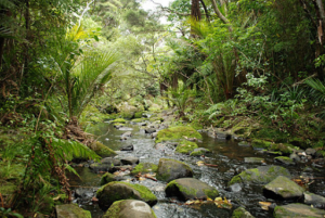
Bush quality
The Auckland Unitary Plan provides limited opportunities for rural subdivision. In terms of the bush protection subdivision pathway, this indigenous vegetation must be of a high quality. Specifically, it must be either identified within the Significant Ecological Areas (SEA) Overlay in the Unitary Plan or meet at least one of the SEA factors identified in Auckland Unitary Plan Policy B7.2.2(1). An Ecologist can assist in determining if bush on your land meets the SEA quality threshold.
Your planner can help you in getting advice from the right specialists, as you need to use people who have experience working in rural environments.
How much bush?
After you’ve identified the vegetation is SEA quality, then we must confirm how much bush is present on your site. Both the quality and the size of the bush area are important. In general terms, the area of SEA quality bush corresponds to the number of new lots you can create- the more SEA quality bush, the more new lots you can create.
Under the Auckland Unitary Plan, the new lots can be created on the site (in- situ) as a new 1ha- 2ha lifestyle site or used as Transferable Rural Site Subdivision Opportunities (TRSS). The TRSS subdivision pathway relates to the “subdivision opportunity” being used on another site in a Countryside Living Zone- the owner of that site buys the TRSS opportunity from you and you legally and physically protect the bush area on your site. You can find out more about this here.
Transferable Rural Site Subdivision Pathway
The Auckland Unitary Plan is geared to incentivise the TRSS subdivision pathway vs in- situ subdivision- the amount of bush required to be protected for a TRSS subdivision is less than if you were wanting to create the new lot in-situ.
The TRSS subdivision pathway requires a minimum of 2ha of bush protection (up to 9.99ha) to create one Transferable Rural Site Subdivision Opportunity. This opportunity would then be transferred to a receiver site within the Countryside Living zone. If you have more than 9.99ha of bush on your site, then you may be able to achieve a greater number of new lots (or “opportunities”). There is no maximum number of TRSS opportunities that you can create using this Auckland Unitary Plan rule (subject to obtaining resource consent), as long as you have sufficient high quality indigenous vegetation on your site.
In- situ Lots
If you wanted to create the new lots on your land (called “in-situ”), a minimum of 4ha of SEA quality bush would require protection to create one new lot. If you had more than 9.99ha of high-quality bush on the site you could create additional sites in-situ in accordance with a sliding scale detailed in in Table E39.6.4.4.1 of the Auckland Unitary Plan. There is a maximum of 12 lots enabled using the bush protection pathway where the sites are created in-situ. This is because rural- residential/ lifestyle development in almost all rural zones is restricted.
The Auckland Unitary Plan rules seek that the new lots should be sized between 1ha-2ha.
What else do I need to consider?
As with all subdivision resource consent applications there are a few other matters that need to be considered if creating lots in-situ:
- Lot layout – is the layout efficient and logical and does it take into account the natural features of the site? Your planner can help to establish a lot layout that is functional for the site.
- Does your site contain highly valuable soils?
- Building platforms/ Specified Building Areas – is there suitable places within the lots to create 2000m2 specified building areas? Are these away from prominent ridgelines or other visually prominent locations and can they meet the zone yard setbacks? Auckland Council is often concerned with the effects on rural character and amenity through the creation of in-situ sites, so the location and prominence of building platforms is important. Assessment by a geotechnical engineer will be required to determine suitability of the building platforms for future development.
- Is there enough area away from the bush, watercourses, wetlands or any natural hazards on the site, that can adequately provide for on-site services such as wastewater disposal fields, stormwater runoff and water tanks? A civil engineer will provide input into the subdivision to determine the best location and design for these systems
- Can the proposed lots be accessed from the road via a vehicle crossing or right of way? Does the right of way need passing bays or does it cross any watercourses or floodplains?
- Does the site have any features such as watercourses, floodplains or natural hazards that need to be considered. And is the watercourse wider than 3m which may potentially trigger an esplanade reserve to be vested?
- Contaminated land – has the land been used for activities listed under the Hazardous Activities and Industries List (HAIL) from the Ministry for the Environment.
- There are a number of rural land activities on this list so it’s important that any areas utilised for these are identified and investigated as needed.
Your planner will help guide your development to take these and other issues into account. Your planner will also have industry contacts to ensure that you get the best team of specialists for your specific rural project. Having the right team is critical to ensure all potential risks, issue and opportunities are addressed from the start.
What will the consent conditions cover?
If you’re successful in obtaining your resource consent, there will be a number of conditions of consent that would be imposed by the Council. These could include:
- Engineering conditions regarding the right of way formation, connection to power, telephone services and potentially fixing of the building platforms.
- Ecological conditions relating to the weed and pest control in the areas to be protected. Any application for resource consent should include a weed and pest control plan prepared by an Ecologist who has undertaken an ecological survey of the bush area.
- Stock proof fencing of the entire bush area with a minimum seven-wire post and wire fence. Generally, no gates are allowed into these areas.
- Surveying conditions including full survey of the bush areas for protection and identification of these on the survey plan.
- Consent notice conditions regarding the legal protection of the bush area and the ongoing obligation to protect these areas
What is the process?
Subdivision in the rural areas can seem like a big undertaking and it’s important to get a team of experienced specialists around you that can assist in making the process as smooth as possible. Having a planner as the lead of the process is important as they will help to identify potential resource consent application and development risks and opportunities, the specialists who are needed and manage those inputs and liaise with the Council on your behalf.
In addition to a Planner, you may also need assessment and inputs from a Surveyor, Geotechnical Engineer, Civil Engineer and an Ecologist. Depending on the site and its characteristics further input may be required and this is something you should discuss with your Planner.
Need more advice?
Development in rural locations is very different to urban areas. Apart from the Council requirements, practical issues like servicing, access, areas to build on and site constraints are very different and need input from professionals experienced in rural development.
Contact us on hello@planningplus.co.nz or (09) 427 9966 to discuss your rural project.
© Planning Plus Ltd 2023
